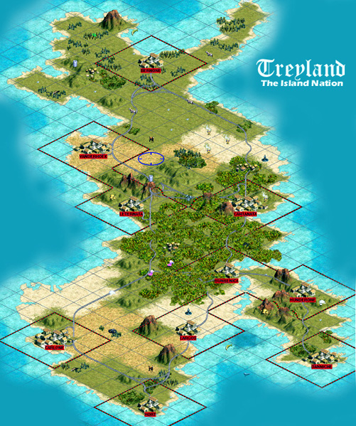
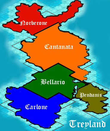
Physical Map of Treyland
 Treyland Geographic Commentary
The geography of Treyland is relatively flat with only scattered mountains; Mount Nori in the north marks Treyland’s highest point. The Cantanata Mountain Range is a short range that extends from the capital, Cantanata, on the east coast to Letenata on the west coast. The Hunderone Range is another small mountain range that separates the Principality of Pendanis from Bellario.
Treyland, in terms of being an island nation, is blessed with abundant natural resources that have help to make Treyland somewhat independent. Aluminum and Uranium are mined in the northern providence of Norberone. This area is referred to as the Thelandic Grasslands. These northern grasslands produce incense and some of the world’s best horses. Coal and petrochemicals dominate the southern Principalities.
Central Treyland is made up of the Cantic forest and various swamps. Dyes are major resources of this central region and, during the 18th century, these dyes counted for the major economic livelihood of Northern Dannunifius.
Treyland Historical Geography
The Cantic forest has contributed much to the historical development of Treyland. It formed a geographic barrier between the ancient Cantanata and Bellario tribes forming a distinct cultural difference between the northern and the southern parts of the country.
This barrier also hampered the efforts of the Dannunifians to invade the whole of the Island Nation in 1841. Dannunifian Armies had occupied the Southern Portion of Treyland for 6 years. In 1850, however, King Stefan ordered his troops to withdraw from Southern Treyland partly due to the Dannunifian Army’s inability to penetrate the Cantic region.
 Treyland Political Geography
Treyland is made up of five Principalities, each governed by a Principal Magistrate. In ancient times these Principalities were the domains of various tribes. Dannesian invaders established a governmental system based somewhat on the Tufan model.
At the same time, the Church established a clerical structure. This required that territory be governed from a central area. As the tribes were conquered and consolidated, seats of government, both in terms of the Church and secular, were established.
The northern principalities are Norberone and Cantanata, named for the tribes that there inhabited. The southern principalities (Bellario, Carlone and Pendanis) are named either for tribes or historical figures.
These initial divisions survive as providences in the modern Elevenistic Nation of Treyland. Treyland began its political history as a Principality of the Kingdom of Dannunifius. In May 1808, Treyland declared itself an independent kingdom. This kingdom existed until it was overthrown in 1938 and replaced by Elevenists from Deutscheslavania. This government, although now more liberal, is still in place.
7 Key Cities of Treyland
Cantanata- Capital of the Nation of Treyland, population 985,456
Carlone- Capital of the Principality of Carlone, population 752,526
Bernone- Capital of the Principality of Norberone, population 705,332
Danniche- Capital of the Principality of Pendanis, population 701,753
Largos- Carlone, population 602,654
Bunbenica- Capital of the Principality of Bellario, population 601,754
Vanderhole- Capital of the Principality of Norberone, population 568,332
Back to Encyclopedia Oddeseana Home
 Treyland Geographic Commentary