
The southern most region of Delasia is called Dannunifian Plains, a large flatland that produces fertile fields and beef meats for most of the continent. Slightly northeast of this grassland is a dense forested area called the Nordanic Weeds.
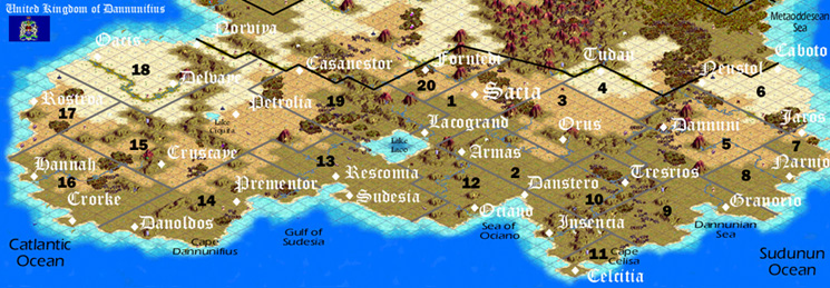
The Kingdom of Dannunifius is divided into 20 Duchies, which span lower Delasia. The Duchy of Oacis (18) is the most arid region of Dannunifius and is often referred to as the Delvayan desert and is located on the Catlantic Ocean. The Nesdor River, which forms the boundary between Deutscheslavania and Dannunifius, is located in the north of the Duchy and the Delvaye River runs through the center starting at the city of Oacis and making its way east to Delvaye.
The Duchy of Oesete (17) is also on the Catlantic, but is not as inhospitable has Oacis. Rostroa is the capital and is known for its exports of fine ivory and, in modern time, petroleum.
Hannah is the capital of the Duchy of the same name (16). This Catlantic duchy is divided by the Orke River, which runs into the central Duchy of Chiquita (15). Chiquita is the largest of the Duchies and is the location of a Lake Chiquita. Additionally the Cayen hills run from central Chiquita north into the Duchy of Oacis.
The Duchy of Sudpredan (14) is located on Cape Dannunifius on the west side of the Gulf of Sudesia and is a producer of various grains. The east side of the Gulf of Sudesia is the Duchy of Rescomia (13) the worlds largest producer of beef and other meats.
Dannunifian Historical Geography
The various mountains have served to confound and protect nations of Delasia and prevent the distinct Delasian cultures from spilling into each other. Aside from the isolation of Treyland, whose Channel was not crossed by Dannunifians and Deutscheslavanians until fairly recently, most Delasian nations evolved their culture through organized conflict. Western Deutscheslavania would be many time a battleground in ancient and modern times, while the eastern parts of the country have been shielding by the mountains.
History began on the Felisorian Peninsula with the founding of Felica by Tufu. Until that time Oddeseans lived as nomadic Pagans on or near the Felisorian Peninsula with a few tribes in southern Delasia and western Stenfine.
Forests have contributed much to the historical development of Delasia. The Nordanic forest was where advanced carpentry developed.